Wednesday, March 28, 2007

Run over by a semi—and still working


Run over something with an 80,000-lb. semi-truck, and you’d expect it to be squashed flat. And, to be honest, we would also expect the same of even our ultra-rugged handheld computers.

But recently, a Recon owned by Quintex Services fell out of a company truck onto one of the busiest streets in Winnipeg, Manitoba. Nobody knows how many cars and trucks may have run over that Recon, but one alert semi-truck driver stopped after he ran over it. He saw the Quintex label on the handheld and returned it to the company. “We really appreciate the driver who brought it back,” says Janette Finnie of Quintex. “He knew it was valuable and returned it.”

Except for some scuffs and a small crack on the touchscreen, the Recon looked no worse for wear. More importantly, it still worked. The next day, it was back on the job, and Finnie reports “it’s working great.”

Quintex delivers uniforms, linens and mats to businesses all over Winnipeg. The company has more than 30 Recons, which drivers use to capture customers’ signatures on electronic invoices when they make their deliveries. The company has been using the handhelds for about a year and chose the Recon after deciding that given their industry and Winnipeg’s harsh winter climate, a commercial-grade handheld wouldn’t be durable enough. The Recon has certainly proven that it is.

And while getting run over by a vehicle is well outside even the Recon's ruggedness specs, we're glad to see that the it has exceeded those expectations.
Wednesday, March 21, 2007

European IT video blog reviews the Recon and Ranger

Think of it as YouTube for IT guys: YourTechTV.com is a video blog site created by European media company Interactive Business Communications (IBC). It features videos and webinars on topics like supply chain logistics and Radio Frequency ID (RFID) as well as with product reviews. Two recent reviews posted on the site feature the Recon and Ranger.


and

Monday, March 19, 2007

Practical tools for forestry management

I performed a demonstration of the new TDS SOLO Forest software at the Winning Technologies in Forestry trade show recently. SOLO Forest is the GIS and mapping solution for forestry applications developed by Tripod Data Systems (TDS), a Trimble company. At the show, we demonstrated the SOLO Forest software as part of a bundled real-time inventory management system, developed by one of our dealers. SOLO Forest is based on TDS SOLO Field mapping software, but with new capabilities specifically for forestry. These include:
  • Grid Generation Tool—This tool allows the user to generate a grid of points to be sampled in a forest stand on their GPS-equipped handheld. The GPS will tell the user how to get to the point; once he’s there, a software interface will call up the timber inventory program so the user can enter measurements on the trees in that plot area. Once all the tree measurement data is collected, SOLO Forest calls up the next plot location on the grid to be sampled, with navigational tools to get the user there. It also marks completed plot points so the user knows when he’s visited all of the points on the grid.


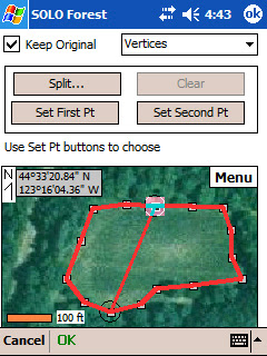
  • Split/Merge Polygon Tool—When collecting data in a forest stand, a user will often find an area that needs to be treated separately because of differences in tree size, species or other factors. With the split tool, a user can map out a separate plot area using GPS or from a map display on the handheld. The merge tool does the opposite when two areas have the same kind or size of trees.


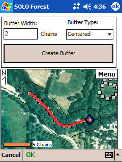
  • Buffer Tool—Many areas require a buffer zone along streams, rivers or wildlife habitats where trees cannot be cut. The buffer tool allows a user to define that zone around a point, line or area. Like the split/merge polygon tool, the buffer tool lets a user define the area using GPS or a map on the screen.


Besides the product demonstration, I also had opportunities to talk with customers and answer their questions. They’re familiar with electronic maps and GIS, but the most common questions were about how SOLO Forest handles different GIS file formats. Fortunately, I could tell them that it works with ESRI Shapefiles, along with projection information, AutoCAD DXF and other common files.

Forestry is one of those outdoor environments where rugged handhelds are proving very popular. With today’s software, mapping and GPS capabilities, they’re practical tools that can help foresters get more accurate data and do it more efficiently.

Friday, March 9, 2007

Spring forward three weeks early—and get your handheld in synch

Daylight Savings Time starts this Sunday, March 11—three weeks ahead of the traditional start. Congress mandated the change in August, 2005 in a bid to save energy. Starting this year, Daylight Savings Time starts on the second Sunday in March and ends the first Sunday in November. So not only are we springing forward earlier, we’re falling back later.

Ranger or Recon handheld computers with Windows Mobile software were designed to switch to Daylight Savings Time automatically—but it’s on the old schedule. The easiest solution is to install the patch from Microsoft. You can download it here: Steps for Windows Mobile. You’ll also find information in our technical bulletin here: 2007_Daylight_Saving_Time_Bulletin.pdf

Monday, March 5, 2007

All together now


When a forester takes one of our handhelds out to do a timber cruise, he may be using multiple technologies, but it all has to work together as one integrated system. That’s the message I got from talking with customers at the Winning Technologies in Forestry trade show earlier this year. They want the electronic maps, GPS, inventory management software and handheld computer to all work together seamlessly.

And with our forest industry partner LandMark Systems, we’ve done just that. LandMark’s RTI real-time inventory package combines our rugged handheld and SOLO Forest software with Tcruise forestry software and GPS. To the forester, though, it’s all one system. And that’s what counts.

Something else I learned at the show is the ruggedness we built into our handhelds has become the accepted standard. Most foresters know the Ranger and Recon work in the woods, so I get fewer questions about their specs. Occasionally, I’ll talk to a customer from Canada who might ask because “it gets pretty cold here, you know.” For the record, their operating temperature ranges from -22 to 140°F (-30 to 60°C).

Monday, February 26, 2007

Blogging from the top (and bottom) of the world—with a Recon


As if climbing the seven highest peaks on the world’s seven continents weren’t enough of a challenge, try doing them all in only seven months. Swedish photographer and adventurer Fredrik Sträng just did—and his 7-7-7 quest marks a new Guiness World Record—191 days. That’s six months and six days from start to finish. These are the seven summits:


1. Everest

2. Denali (Mt. McKinley)

3. Elbrus

4. Puncak Jaya

5. Kilimanjaro

6. Aconcagua

7. Vinson Massif
Asia

North America

Europe

Oceana

Africa

South America

Antarctica
8,848 m (29,029 ft.)

6,194 m (20,320 ft.)

6,642 m (18,513 ft.)

4,884 m (16,023 ft.)

5,895 m (19,340 ft.)

6,962 m (22,841 ft.)

4,897 m (16,067 ft.)


During his expedition, Fredrik constantly updated his blog using a Trimble Recon. Blogging from some of the harshest outdoor conditions in the world, he found the Recon worked without problems, even at temperatures as low as -30 C and altitudes up to 6,400 meters.

Fredrik’s expedition will be published in a book coming out in September. A one-hour English-language documentary will be released in early 2008.


Friday, February 23, 2007

The other white meat—a huge potential market for rugged handhelds


So what’s a company that makes rugged handheld computers doing at a trade show like the Iowa Pork Congress? Well, it turns out that pig farmers are pretty computer savvy—and the inventory tracking and animal management they need to do are ideal applications for rugged handhelds.

A typical commercial pig farm could have tens of thousands or hundreds of thousands of animals, and farmers not only need to keep track of them all, but they also need to manage medication and feeding regimens. They also have to monitor pregnant sows, along with the birth weights and progress of their piglets.

About half of the software companies that serve this market are offering Windows Mobile versions, and the rest are heading in that direction. They’re also moving toward RFID for tracking individual animals. Plus, since pig farms tend to be smaller than cattle ranches, they can be readily set up with WiFi coverage. That means information collected on the handheld can be sent back to the office in real time.

Of course, when you think of pigs, you often think of mud. Which is why a rugged handheld makes so much sense when you’re working in this kind of environment. And pig farmers are often working outside in bad weather as well.

We didn’t know what to expect at the show, but the people we met in Iowa are definitely interested.