Wednesday, May 30, 2007
We've moved!
We've moved to OutdoorRugged.com
For more blogs, videos and a new forum, it's the place to be for outdoor professionals.
Wednesday, May 2, 2007
Get a little bit more from your GPS
What I like best about this little program is its simplicity. After downloading the application, all I had to do was set the serial port to COM4 (the Microsoft GPS sharing port), and the data started flowing in.
The first screen shows the traditional signal strength indicators:

The second screen shows an advanced satellite plot page with the predicted paths of each satellite:

The third screen shows an innovative dashboard with common cockpit-style indicators for speed, altitude, direction, and vertical speed:

The final screen could be the most useful to some people. It shows statistical averages of position with standard deviation and least squares average:

In short, this little program gives you the information you need from your GPS without being difficult to configure. Out of all the status applications I have tried (including the application that ships with the Holux GPS card), this is the one I keep coming back to because I know it will always work.
If you like this app, Visual GPS also makes a more advanced program, BeeLineGPS, that’s $29.95 with a 30-day free trial.
Tuesday, April 17, 2007
Portland Police use rugged handhelds to write electronic tickets

Just like police cars that are beefed up with heavy-duty components, the Recon rugged handheld is built to withstand the rigors of police work. Officers in Portland, Ore. use the handhelds for writing electronic tickets, dispatch and for real-time connections to motor vehicle, National Crime Information Center (NCIC) and other databases. Using the handhelds, officers save time on traffic stops and have improved the accuracy of traffic citations.
http://www.trimble.com/pdxpolice
Friday, April 13, 2007
Denver Fire Department saves 4,000 hours a year using rugged handhelds for fire safety inspections

The Denver Fire Department is able to capture three times as much information, saves 4,000 labor hours a year, and has eliminated about 60,000 sheets of carbonless paper by conducting its fire safety inspections using a rugged Recon handheld.
www.trimble.com/denverfire
Wednesday, April 11, 2007
Erasing battery memory effect
Unlike older NiCad batteries, which suffered from shortened battery life after multiple partial discharge cycles, the Recon’s NiMH batteries are generally not susceptible to this “memory effect.” Still, we’ve had some calls from customers reporting that the low battery warning is showing up much earlier on their Recons.
Jan Gallant from our tech support department looked into the problem, did some tests, and has a solution: a deep discharge of your Recon’s battery, followed by a full 12-hour recharge. Details are in this product bulletin
Tuesday, April 3, 2007
Rugged from the inside out
There’s much more to building a rugged handheld than putting a sturdy case around a commercial-grade PDA. And while all our handhelds meet the MIL-STD-810F military standard for durability and come with an IP67 rating against water and dust, we design and test them to withstand a lifetime of real-world customer use, not just to meet a spec.
Jerry Steiger, a mechanical engineer who has worked on three generations of our rugged handhelds, shows how they’re built tough from the inside out. You’ll also see how the designs have evolved to save weight and reduce costs while not compromising ruggedness.
Thursday, March 29, 2007
New GPS card keeps you from going in circles
I set out to test whether a Recon equipped with this new card will show the improved reception. Finding tree cover is something that is easily done in the mountains of Western Oregon. To conduct the test, I set up two identical Recon X-Series units with extended caps and TDS TerraGuide software. I installed the new Holux GR-271 GPS card in one and an older Holux GPS card in the other.
 For the test location, I picked the most rugged terrain with dense tree cover, Old Growth Trail, near Corvallis. Not only does this trail go through a steep valley with limited view of the sky, but it also goes through a stand of 250 year-old trees that absorb faint GPS radio signals. I walked the route with both units running side-by-side so they would experience the same conditions. As you can see from the photo above, it was raining the entire trip.
Here’s a screen shot from TerraGuide of the trip. The new Holux GPS is colored green and the old Holux GPS is colored red.
 Although the aerial photo is about 25 years old (the clear-cut area in the top left is now covered with trees), you can see that the route starts on a forest road and then turns off into an area with large trees. The new Holux GPS showed a satellite fix for the entire trip, while the older GPS only showed a fix for about half the trip.
Looking closely at the tracks above you can see that the Holux GR-271 GPS closely follows the road (white in the photo), while the old GPS wanders 50 to 100 feet from the mark. When you reach the large trees this situation gets even worse. You can see that the old card only got a couple fixes on the trail (visible as long straight lines), while the new card got a fix every 10 feet (shown by smooth contours in the track). In some places (near the far right), spurious fixes actually showed the track looping itself—something the trail certainly did not do.
Although this is only one real-world test, the new Holux GPS appears to record tracks much better than the old card. With any luck, this will translate into better performance of the Recon with GPS for outdoor navigation, GIS mapping and forestry applications (like TDS SOLO Forest). At least it will keep you from going in circles.
Wednesday, March 28, 2007
Run over by a semi—and still working


Run over something with an 80,000-lb. semi-truck, and you’d expect it to be squashed flat. And, to be honest, we would also expect the same of even our ultra-rugged handheld computers.
But recently, a Recon owned by Quintex Services fell out of a company truck onto one of the busiest streets in Winnipeg, Manitoba. Nobody knows how many cars and trucks may have run over that Recon, but one alert semi-truck driver stopped after he ran over it. He saw the Quintex label on the handheld and returned it to the company. “We really appreciate the driver who brought it back,” says Janette Finnie of Quintex. “He knew it was valuable and returned it.”
Except for some scuffs and a small crack on the touchscreen, the Recon looked no worse for wear. More importantly, it still worked. The next day, it was back on the job, and Finnie reports “it’s working great.”
Quintex delivers uniforms, linens and mats to businesses all over Winnipeg. The company has more than 30 Recons, which drivers use to capture customers’ signatures on electronic invoices when they make their deliveries. The company has been using the handhelds for about a year and chose the Recon after deciding that given their industry and Winnipeg’s harsh winter climate, a commercial-grade handheld wouldn’t be durable enough. The Recon has certainly proven that it is.
And while getting run over by a vehicle is well outside even the Recon's ruggedness specs, we're glad to see that the it has exceeded those expectations.
Wednesday, March 21, 2007
European IT video blog reviews the Recon and Ranger
and
Monday, March 19, 2007
Practical tools for forestry management
- Grid Generation Tool—This tool allows the user to generate a grid of points to be sampled in a forest stand on their GPS-equipped handheld. The GPS will tell the user how to get to the point; once he’s there, a software interface will call up the timber inventory program so the user can enter measurements on the trees in that plot area. Once all the tree measurement data is collected, SOLO Forest calls up the next plot location on the grid to be sampled, with navigational tools to get the user there. It also marks completed plot points so the user knows when he’s visited all of the points on the grid.
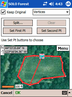
- Split/Merge Polygon Tool—When collecting data in a forest stand, a user will often find an area that needs to be treated separately because of differences in tree size, species or other factors. With the split tool, a user can map out a separate plot area using GPS or from a map display on the handheld. The merge tool does the opposite when two areas have the same kind or size of trees.
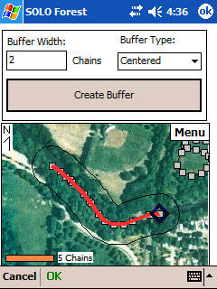
- Buffer Tool—Many areas require a buffer zone along streams, rivers or wildlife habitats where trees cannot be cut. The buffer tool allows a user to define that zone around a point, line or area. Like the split/merge polygon tool, the buffer tool lets a user define the area using GPS or a map on the screen.


Besides the product demonstration, I also had opportunities to talk with customers and answer their questions. They’re familiar with electronic maps and GIS, but the most common questions were about how SOLO Forest handles different GIS file formats. Fortunately, I could tell them that it works with ESRI Shapefiles, along with projection information, AutoCAD DXF and other common files.
Forestry is one of those outdoor environments where rugged handhelds are proving very popular. With today’s software, mapping and GPS capabilities, they’re practical tools that can help foresters get more accurate data and do it more efficiently.
Friday, March 9, 2007
Spring forward three weeks early—and get your handheld in synch
Ranger or Recon handheld computers with Windows Mobile software were designed to switch to Daylight Savings Time automatically—but it’s on the old schedule. The easiest solution is to install the patch from Microsoft. You can download it here: Steps for Windows Mobile. You’ll also find information in our technical bulletin here: 2007_Daylight_Saving_Time_Bulletin.pdf
Monday, March 5, 2007
All together now

When a forester takes one of our handhelds out to do a timber cruise, he may be using multiple technologies, but it all has to work together as one integrated system. That’s the message I got from talking with customers at the Winning Technologies in Forestry trade show earlier this year. They want the electronic maps, GPS, inventory management software and handheld computer to all work together seamlessly.
And with our forest industry partner LandMark Systems, we’ve done just that. LandMark’s RTI real-time inventory package combines our rugged handheld and SOLO Forest software with Tcruise forestry software and GPS. To the forester, though, it’s all one system. And that’s what counts.
Something else I learned at the show is the ruggedness we built into our handhelds has become the accepted standard. Most foresters know the Ranger and Recon work in the woods, so I get fewer questions about their specs. Occasionally, I’ll talk to a customer from Canada who might ask because “it gets pretty cold here, you know.” For the record, their operating temperature ranges from -22 to 140°F (-30 to 60°C).
Monday, February 26, 2007
Blogging from the top (and bottom) of the world—with a Recon

As if climbing the seven highest peaks on the world’s seven continents weren’t enough of a challenge, try doing them all in only seven months. Swedish photographer and adventurer Fredrik Sträng just did—and his 7-7-7 quest marks a new Guiness World Record—191 days. That’s six months and six days from start to finish. These are the seven summits:

| 1. Everest 2. Denali (Mt. McKinley) 3. Elbrus 4. Puncak Jaya 5. Kilimanjaro 6. Aconcagua 7. Vinson Massif | Asia North America Europe Oceana Africa South America Antarctica | 8,848 m (29,029 ft.) 6,194 m (20,320 ft.) 6,642 m (18,513 ft.) 4,884 m (16,023 ft.) 5,895 m (19,340 ft.) 6,962 m (22,841 ft.) 4,897 m (16,067 ft.) |

During his expedition, Fredrik constantly updated his blog using a Trimble Recon. Blogging from some of the harshest outdoor conditions in the world, he found the Recon worked without problems, even at temperatures as low as -30 C and altitudes up to 6,400 meters.
Fredrik’s expedition will be published in a book coming out in September. A one-hour English-language documentary will be released in early 2008.
Friday, February 23, 2007
The other white meat—a huge potential market for rugged handhelds

So what’s a company that makes rugged handheld computers doing at a trade show like the Iowa Pork Congress? Well, it turns out that pig farmers are pretty computer savvy—and the inventory tracking and animal management they need to do are ideal applications for rugged handhelds.
A typical commercial pig farm could have tens of thousands or hundreds of thousands of animals, and farmers not only need to keep track of them all, but they also need to manage medication and feeding regimens. They also have to monitor pregnant sows, along with the birth weights and progress of their piglets.
About half of the software companies that serve this market are offering Windows Mobile versions, and the rest are heading in that direction. They’re also moving toward RFID for tracking individual animals. Plus, since pig farms tend to be smaller than cattle ranches, they can be readily set up with WiFi coverage. That means information collected on the handheld can be sent back to the office in real time.
Of course, when you think of pigs, you often think of mud. Which is why a rugged handheld makes so much sense when you’re working in this kind of environment. And pig farmers are often working outside in bad weather as well.
We didn’t know what to expect at the show, but the people we met in Iowa are definitely interested.
Monday, February 19, 2007
Recon Street Navigator, Google vs. Microsoft
Since both products provide almost identical interfaces, the main differentiating features are map quality and usability. After starting the application, Google shows you a map instead of a search screen as Microsoft does.
Entering a search is very text oriented on Google Maps. You enter the type of search you want (i.e. Hardware stores), then the city and state. Live Search Mobile lets you choose from a series of lists – something that is much easier to do if you are in a car.
The results look similar in both programs, except that Google presents maps that are somehow cleaner and easier on the eyes. In addition, the Google Maps traffic mapping is much easier to see because both sides of traffic are clearly drawn. The color indicates speed: Green (over fifty mph), Yellow (between 26 and 50 mph), Red (less than 25 mph).


The directions feature operates very similarly in both programs, except that Google Maps shows each step on the map, not on a list. A GPS will center the map based on your location.


The best feature on Google Maps, and the one that sold me on the program, was the map quality. While Windows Live showed black and white aerial photos of many areas, Google Maps seems to have many more updated color maps – even in rural areas. For example, our small city of Corvallis, Oregon is completely in color on Google Maps. Here is a comparison of the Trimble building on both services (Oops, the Windows Live map is so old that our building isn’t even on it! We built it almost 10 years ago).


So, now you have a choice between two very similar applications for your Recon or Ranger. Since they are both free, try them both out before deciding. You will need to attach a GPS (Bluetooth, or Holux CompactFlash card) and a GPRS data connection (wired or Bluetooth to a cell phone) to your device before hitting the road.
Visit http://www.google.com/gmm to download Google maps and http://wls.live.com for the Microsoft application and let us know what you think. Just remember, with a GPS and maps like these, you won’t be able to use getting lost as an excuse anymore.
Tuesday, February 13, 2007
Testing for unique customer requirements
Hi! My name is Alex. I am a member of Tripod Data Systems’ engineering team. I am responsible for successful execution of customer-focused projects, also known as tactical projects. Our customers call us for unique configurations, and I get to test the limits of our products to see if they can handle the conditions stated in the customer request.
I created this video of me testing the buoyancy of a Recon mated with an Extended Cap off the jetty on the Oregon Coast near Yaquina Bay. The Recon is thrown out into the water several times, and it survives the ordeal of hitting the water and banging against the rocks when I haul it to shore!
Tuesday, February 6, 2007
Recon Street Navigator
The first thing to understand about this product is that the name “Search” in the title can be a bit confusing. To me, search brings up images of a classic search engine that returns web sites matching your keywords. However, Microsoft has taken a very broad view of search to include: maps, traffic, turn-by-turn directions, GPS integration and local business search tools.
The integration of all these search tools comes together very nicely in the application. If you are trying to find the phone number of a business, find a map of an area, get directions, or decide which interstate has less traffic, this application is for you. Here is what the startup page looks like.

Finding a business works quite well. Because the list of categories is geared toward consumer use, you have to enter the category by hand instead of choosing from a list. By clicking, “Map all” each location is shown on a map. You can also view traffic information on the map for larger cities (shown in red, yellow, green interstate highlighting).

Where all of these features come together is the integration with a GPS. To get setup, you will need to attach a GPS (Bluetooth, or Holux CompactFlash card) and a GPRS data connection (wired or Bluetooth to a cell phone) to your Recon. Using the hardware store search from above, I clicked on one of the entries, and requested “Directions to Here” starting from “My current location”. Using your current GPS position, the program generates a clear set of directions and shows them on a map.

With a Ram-Mount for your Recon you could even navigate to job sites with this handy feature. Although the program does not read the directions to you out-loud like high-end car navigation systems, the application moves the map to show your current position. This makes it possible to keep track of where you are on a map.
The greatest part about this application is that it is currently free from Microsoft. The program is still in beta, but I didn’t find any major features that didn’t work.
To run this program on your Recon or Ranger, first get set up with a GPS and a GPRS data connection. From Internet Explore on the device, visit http://wls.live.com and download the application. Within a minute or two you will turn your handheld computer into a handy street navigator. Just remember, your Recon may get you to the job site, but someone still has to do the work.
Thursday, February 1, 2007
Human-powered transatlantic crossing—with a Recon for navigation
No one in history has traveled further in 24 hours under his own power than Greg Kolodziejzyk. In July 2006, Greg pedaled his human-powered vehicle more than 650 miles in just 24 hours, setting a new world record.
And no one has ever pedaled a human powered boat across the Atlantic Ocean—solo and unsupported. But Greg will—and his only companion will be the Recon.
As Greg explains in his own blog (www.PedalTheOcean.com):
“Crossing the ocean in a 24-inch-wide pedal boat is serious business. I can’t afford to take chances with my equipment. That’s why I selected Trimble’s ultra-tough Recon PDA as my primary navigation and communications device.”
Besides running GPS navigation software, Greg will also use the Recon and a satellite phone to send us updates, as well as upload photos and videos along the way.
Monday, January 29, 2007
Ranger out of the box
The out-of-the-box experience with the Ranger is almost the same as with the Recon (featured in a previous video). However, you only need to charge the lithium-ion battery for 4 hours before connecting it to the Ranger.
Wednesday, January 24, 2007
Check out these accessories
Accessories can make your Recon and Ranger handheld even more versatile. The latest models are available with built-in Bluetooth and 802.11g wireless, but you can also add those capabilities—and many others—using the two CompactFlash slots.
Monday, January 22, 2007
Recon out of the box
Here’s what you get when you take your Recon out of the box. An important tip to remember is you need to fully charge the NiMH battery before connecting it to the Recon—about 12 hours. After that, you’re ready to go!
Wednesday, January 10, 2007
Now it’s your turn
| Now that you’ve seen how we test our rugged handhelds, it’s your turn. Tell us about the rough outdoor conditions where you use the Recon or Ranger. Share your stories, pictures and videos, and we’ll post them here. Remember, everybody who contributes gets a Trimble hat, and we’ll give out bigger prizes for the best stories. | |
Accelerated life testing
| How do you pack years of real-world use when you don’t have years to complete a test program? That’s where accelerated life testing comes in. You’ll see how one of our accelerated testing machines performs hundreds of thousands of taps on the Ranger’s touchscreen and keypad—the equivalent of a complete product lifecycle—in just six to 18 hours. | |
Prototype testing lab
| You could call our prototype testing lab the Torture Chamber. It’s where we bake, freeze and soak our rugged handhelds before they go to a third-party lab for certification. You’ll see handhelds going through extreme temperature testing in our 65º C chamber and -35º C deep freeze. And you’ll see a MIL-STD immersion test, where we sink a running Recon in 1 meter of water. | |


